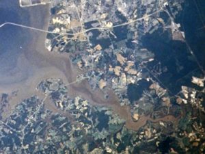
Located in Norfolk, the Lafayette River is one of Hampton Roads’ most important tributaries. The Lafayette joins the Elizabeth River just south of Sewell’s Point, near the Port of Hampton Roads.
During the colonial period, the waterway was known as Tanner’s Creek.
Several landmarks are located along the Lafayette River. Near its mouth is the Hermitage Museum and Gardens. Along the river’s west bank is Lafayette Park and Virginia Zoological Park.
Lafayette River Restoration
The Lafayette River has been closed to oyster harvesting for decades due to poor water quality. After years of restoration efforts, stakeholders have reported a number of improvements in water quality.
Due to its good natural spat set, the presence of several oyster restoration projects, non-harvest status, size, and strong interest from watershed groups, the Lafayette River is the site of a large-scale oyster restoration project; one of the ten called for by the Chesapeake Bay Watershed Agreement.
Restoration partners in the Lafayette Oyster Restoration Workgroup are led by NOAA and include the U.S. Army Corps of Engineers, the Chesapeake Bay Foundation, the City of Norfolk, the Elizabeth River Project, the Virginia Institute of Marine Science, and Christopher Newport University. Since 2010, partners have provided support for more than 10 acres of new reefs.
A NOAA survey found that the Lafayette River has approximately 60 acres of oyster habitat, in addition to the restoration sites. Independent oyster population surveys conducted by the Army Corps/Christopher Newport University and by NOAA/Virginia Institute of Marine Science show that the Lafayette River contains natural, functioning oyster reefs on grounds that have not been disturbed or harvested for many decades.
Related Information